The Autumn Weather Thread


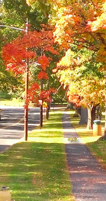

Friday September 11th
Today we start with a mix of clouds and sun, maybe even a chance of sprinkles, then mostly sunny, dry with low humidity and a bit of breeze. High around 80⁰, overnight clear, low near 60⁰
Saturday warm, dry (during the day), gathering clouds. High near 80⁰
Saturday night into Sunday, rain, likely becoming heavy at times, perhaps a thunderstorm. Timing is still unknown but we could see a period of quite heavy rain somewhere in the period, and possibly a bit of flooding in the usual places. Rain tapers off Sunday afternoon. High Sunday lower 80⁰s, low Sunday night mid 60⁰s
Monday and Tuesday still looking nice, highs upper 70⁰s, less humid, lows near 60⁰ overnight


Max, as one of the folks I never disagree with about the weather I shall give you grace here to call this thread Autumn when the autumnal equinox still awaits. Love this season regardless of when it officially starts. 
Meteorologists live by their own rules: Autumn The season of the year that is the transition period from summer to winter, occurring as the sun approaches the winter solstice. Meteorological autumn (different from standard/astronomical autumn) begins September 1 and ends November 30.
https://www.ncei.noaa.gov/news/meteorological-versus-astronomical-seasons


max_weisenfeld said:
Meteorologists live by their own rules: Autumn The season of the year that is the transition period from summer to winter, occurring as the sun approaches the winter solstice. Meteorological autumn (different from standard/astronomical autumn) begins September 1 and ends November 30.
https://www.ncei.noaa.gov/news/meteorological-versus-astronomical-seasons
Sumac and Poison Ivy leaves are already turning red. Fall plants in the Swamp are now in bloom, including accopanying "stick tight" seeds. I spent two hours yesterday, chopping the seed weeds off of the trails so that hikers don't spend 1/2 hour or more at home, pulling them off of their clothes.

max_weisenfeld said:
Sunday, might rain but nothing serious so far
it's feeling more serious now:
Showers with heavy downpours and a few thunderstorms early Sunday morning into midday Sunday may lead to flooding. Average rainfall amounts are forecast to range from 1.5 to 3 inches with locally higher amounts of 5 to 7 inches possible. Peak hourly rates could reach 2 to 2.5 inches. - http://www.weather.gov/safety/flood
max_weisenfeld said:
Friday September 11th
Saturday night into Sunday, rain, likely becoming heavy at times, perhaps a thunderstorm. Timing is still unknown but we could see a period of quite heavy rain somewhere in the period, and possibly a bit of flooding in the usual places. Rain tapers off Sunday afternoon. High Sunday lower 80⁰s, low Sunday night mid 60⁰s
Keep up, Jamie :-D
FWIW we've had just under 2" as of 11am

max_weisenfeld said:
Keep up, Jamie :-D
FWIW we've had just under 2" as of 11am
I had just a smidge under 2" total - at least that's what was in my rain gauge after the sun came out. (Your weather is my weather!  )
Monday September 14th
Mild dry air blows into the area today, a nice weather week ahead
Today, breezy, cooler, becoming sunny, with a high in the mid 70⁰s
Tonight, clear, chilly, low in the low 50⁰s
Tuesday sunny, high in the low 70⁰s, low in the upper 50⁰s
Wednesday and Thursday, mostly sunny, high around 80⁰, low in the mid 60⁰s, very slight chance showers overnight Thursday into Friday
Friday, sun and clouds, high around 80⁰
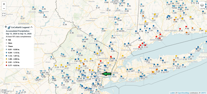
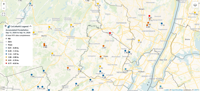
The storm over the weekend is a classic example of a narrow band of rain and why it can be hard to predict total rainfall. I measured 1.58" over the entire course of the storm. Here are two views of the rainfall map showing the track the storm too and highlighting how we can have 1.58" in Eastern Maplewood, 2.31" in South Orange, Livingston gets 3.02", and places in Bergen County got close to 6.00"
In the wider angle view there is a green arrow pointing to Maplewood. You can see how the heaviest rain tracked up the north coast of Long Island Sound through Connecticut

Thanks Max. My favorite parts of these forecasts are your explanations.

DanDietrich said:
Thanks Max. My favorite parts of these forecasts are your explanations.
What he said
Wednesday September 16th
Today, more sun than clouds, a bit warmer, and a bit more humid. High around 80⁰, overnight down to the mid 60⁰s
Thursday clouds, a slight chance of a light shower afternoon into evening, high low 80⁰s, low upper 60⁰s
Friday clearing, high around 80⁰, less humid, low overnight upper 50⁰s
The weekend weather still not locked in, but Saturday looks like a mix of sun and clouds, high only around 70⁰. Overnight there's a chance of light showers, low around 60⁰
Showers likely Sunday, but not heavy rain. High around 70⁰, low around 60⁰
Chance of showers continues into the first half of next week
Friday September 18th
Enjoy the next two days, they should be nice
Today, sun and clouds as the air dries out, high around 80⁰, overnight low very autumnal in the upper 50⁰s
Saturday more clouds than sun high in the low 70⁰s low around 60⁰
Sunday chance of light rain becomes rain likely in the afternoon and evening, high in the upper 60⁰s low in the lower 60⁰s rain could be heavy at times
The rest of next week is unsettled with a 50/50 chance of rain throughout, should have more clarity early next week
I won't be posting again until Tuesday. Wishing you an easy fast to those who are observing
Tuesday September 22nd
Shorten sails and wear a jacket, cool days and gusty north winds ahead!
Today, still a chance of a light shower this morning, then cloudy, breezy, and cool. Winds from the northeast. High mid 60⁰s, overnight low lower 50⁰s
Wednesday, sun and clouds, gusty winds could hit 30mph, mid 60⁰s, overnight near 50⁰
Thursday, more sun than clouds, northeast wind continues to blow and gust up to 30mph, mid 60⁰s and around 50⁰
Friday and Saturday, chance of showers, wind swings around to the north and might even pick up a bit, highs mid 60⁰s lows mid 50⁰s
As of this morning the NWS has not issued any Advisories regarding the winds, and if the forecast holds the winds will stay at this level and just blow the leaves around vigorously. A high pressure to our north and a deep low to our south do present a steep pressure slope all week so we will keep an eye on that


“high pressure to our north and a deep low to our south do present a steep pressure slope all week so we will keep an eye on that”
Is this why all the internet meteorologists are bouncing up and down in their chairs… warning us of impending runs for bread and milk? Maybe it’s related to the full moon on Saturday…
Jaytee said:
“high pressure to our north and a deep low to our south do present a steep pressure slope all week so we will keep an eye on that”
Is this why all the internet meteorologists are bouncing up and down in their chairs… warning us of impending runs for bread and milk? Maybe it’s related to the full moon on Saturday…
No, there is actually a storm out there in the Atlantic later this week. Where that pressure gradient does affect things is that about half the models have that storm backing in towards us after it passes, and half don't (the high blocks it, but where does it block it towards?). Latest trend is away from us but the increments from model run to model run are small. So for now we watch and wait -- but it is likely not as huge for us here in either scenario as it would be for eastern Long Island and north into Boston.
Thursday, September 24th.
This weekend, the area will be affected by a coastal storm. How significant the effects will be is a matter of some dispute, both among the models and even between the national weather service Philadelphia and New York offices
What we do know:
A coastal storm developing off Maryland will track north and east Friday, possibly bringing showers and moderately breezy conditions to the area Friday and likely showers and gusty winds Saturday. The storm will then head north towards the Massachusetts coast
What we don't know:
A large high pressure area over Quebec could either nudge the storm out to sea or push the storm back onto the New York/New Jersey coast. If the storm moves back ("retrogrades" in weather talk) it could bring more rain and wind to our area over the weekend.
What won't happen:
We really do not expect this to be a severe storm in our area under ether scenario. Most likely, we will see showers and breezy to gusty, wind conditions Saturday and Sunday. Some showers could be heavy at times. There will be more significant weather conditions out on Long Island and these are likely to influence the weather reports you hear on TV and see on the internet
Today, sun and clouds, high upper 60⁰s, low mid 50⁰s and breezy
Tomorrow gathering clouds in the afternoon, breezy, and a chance of a shower. High near 70⁰, low upper 50⁰s
Saturday showers likely, especially in the afternoon, gusty and breezy, high mid 60⁰s, low mid 50⁰s
Sunday showers likely, possibly heavy at times but little flood risk. Gusty and breezy winds, high mid 60⁰s, low mid 50⁰s
The early part of next week looks mostly sunny and a little warmer

The amount of forecast uncertainty around this storm given such a short lead time is crazy. This thing is a beast but nobody knows where it’s going.
WxNut2.0 said:
The amount of forecast uncertainty around this storm given such a short lead time is crazy. This thing is a beast but nobody knows where it’s going.
I still think the jersey shore will get the worst of it. With the high tide and the storm churning up the ocean, pushing the water onshore. It is a huge storm.
Friday, September 25th update
Over the last few model cycles (most of the models update every six hours) there has been a bit more agreement although there is still an abnormally high range of possible storm tracks. The general trend has been westward and more on shore, with a fully out to sea track becoming less likely. What this means to us is it is more likely we will see showers tonight giving way to steady rain Saturday morning that could continue through Sunday night with showers possible through Monday. Winds are forecast to be steady 20 to 25mph with gusts up to 40mph. The NWS has issued a Wind Advisory for the entire weekend.
This will be the first nor'easter of the season. The weather is still forecast to be much worse to our east, along the coast and Long Island, and we should expect the media to focus on that
Although total rain for us is expected to be 1 - 3 inches, it will fall over a two day period. That should limit flooding to minor road ponding and field flooding
The wind could be more of an issue as the trees are still mostly in leaf and by Sunday the ground should be quite soggy. Still, although this could be a still blow at this time we should not expect widespread damage here. As with the rain, though, the coastal areas would expect to be affected more
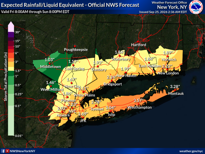
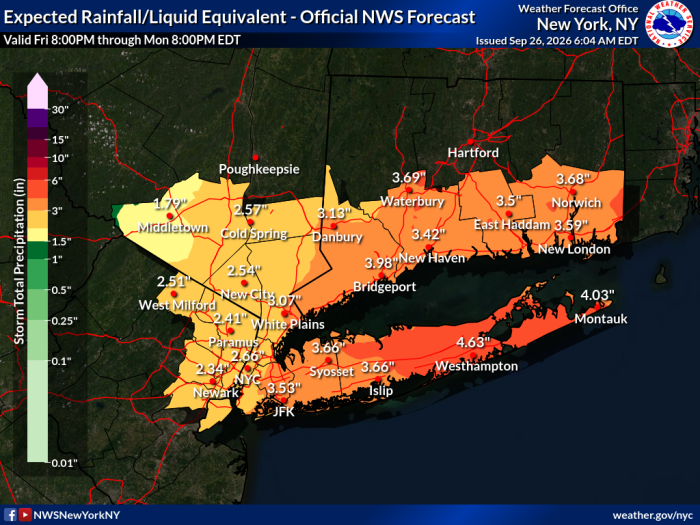
The graphic below is from the NWS and shows the total rainfall they expect over the multi-day period. We are in the 1½ - 2 inch zone on that forecast
From the NWS:
URGENT - WEATHER MESSAGE
National Weather Service Upton NY
Issued by National Weather Service Mount Holly NJ
431 AM EDT Fri Sep 25 2026
CTZ005-006-NJZ004-006-103>108-NYZ069-070-252000-
/O.EXA.KOKX.WI.Y.0003.260925T1800Z-260927T1000Z/
Northern Fairfield-Northern New Haven-Eastern Passaic-Hudson-
Western Bergen-Eastern Bergen-Western Essex-Eastern Essex-
Western Union-Eastern Union-Rockland-Northern Westchester-
431 AM EDT Fri Sep 25 2026
...WIND ADVISORY IN EFFECT FROM 2 PM FRIDAY TO 6 AM EDT SUNDAY...
* WHAT...North winds 20 to 25 mph with gusts up to 55 mph
expected.
* WHERE...Portions of southern Connecticut and southeast New
York.
* WHEN...From 2 PM Friday to 6 AM EDT Sunday.
* IMPACTS...Gusty winds will blow around unsecured objects. Tree
limbs could be blown down and a few power outages may result.
PRECAUTIONARY/PREPAREDNESS ACTIONS...
Winds this strong can make driving difficult, especially for high
profile vehicles. Use extra caution.
Secure outdoor objects.
&&
$$
Friday evening update 9/25
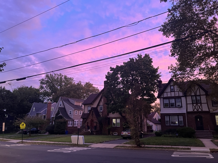
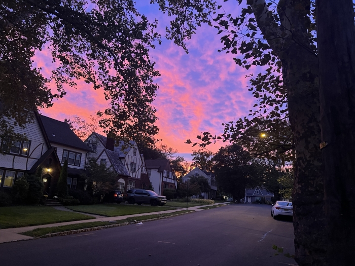
I hope everyone got to see that sunset. That was thanks to the nor'easter!
While there is still some spread to the forecast models, the trend is slower and mostly more to the west. We might see some showers tonight, more likely towards morning. Breezy, with frequent gusts is the 35mph range
Saturday morning showers and rain, light to moderate, and windy -- steady winds in the 20 - 25mph range with gusts up to 40mph. This wind can blow light things around and could bring down a branch or two
Rain likely to be more consistent and steady in the afternoon, the we might get a break in the evening. By which I mean showers continue but less steady rain. The wind also continues
Over night and Sunday, moderate steady rain all day. wind continues in the 20-25mph range but the gusts abate a little, probably in the 35mph area
Rain and wind likely to continue overnight Sunday, and should taper off during the day Monday
Although rain forecast is now in the 3 - 4 inch range, this is over a 48 hour period, so flooding here is likely to remain minor. The river can handle this intensity, though the ground will become saturated and we probably will see some road ponding and field flooding in the usual places
And just remember, the media are going to be focused on the coast and Long Island, where things are going to be appreciably worse. For us this is likely a messy long duration rainfall with persistent Advisory-level winds. We have been experiencing 20mph winds with 30- gusts all day already, as a point of reference
Saturday, September 26th update, 8:00 am
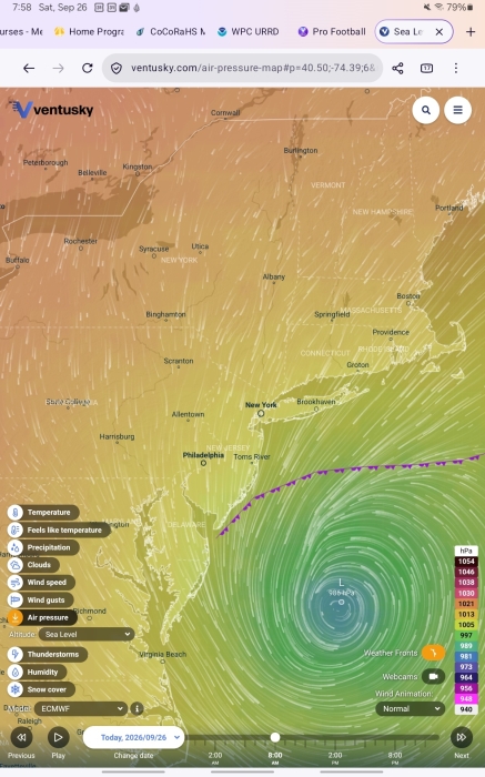
The forecast remains fairly consistent for this weekend's storm, Wind Advisory continues
Light rain and windy this morning. Steady winds at 20 - 25mph with gusts in the 35 - 40mph range. Rains should remain intermittent and fairly light today, and we may even see a dry slot this afternoon for awhile, as the storm slowly works its way up the coast
Steadier rains tonight, mostly moderate though we might see a heavier band or two come through, and we may even hear a bit of thunder after midnight. However, the NWS still considers the flood risk away from the coast (ie here) to be minimal, just normal road ponding and minor field flooding. Winds should continue at around 20 - 25mph with gusts to 40mph
Sunday showers continue as the storm starts to break up and drift back towards us a bit. Winds begin to abate, 15 - 20mph average but still gusts in the high 30mph range, with this trend continuing through the night
Monday showers ending eventually, still a bit breezy, especially in the morning
Temps in the 60⁰s throughout, *total 3 day* rain of 2 - 3 inches

I’ve been reading about awful floods around the NJ coast and low-lying areas. Also widespread electrical outages. I hope everyone in MOL-land is safe and dry.
joanne said:
I’ve been reading about awful floods around the NJ coast and low-lying areas. Also widespread electrical outages. I hope everyone in MOL-land is safe and dry.
See Max's posts - As almost always is the case, they are spot on! It's actually not been raining here for a few hours this afternoon.
jamie said:
That was pretty awesome
Beautiful! (I have a photo almost identical to your second one that I posted on Facebook, but I won't repeat you here. Those colors were certainly amazing!)

Just checked the JCPL and PSEG outage maps and I'm not seeing any in MAPSO or Millburn.
Sunday September 27th update.
After a rainy night, we find ourselves once again dry slotted. Light showers likely to continue this morning and into the early afternoon. In late afternoon, rain will likely begin to pick up again as the storm retrogrades back into our area. Wind continues this morning in the twenty to twenty five mile per hour range with gusts in the upper thirties. As the rain picks up this afternoon and the storm begins to break up, wind will lkely begin to abate, but still be near twenty miles an hour with thirty mile an hour gusts. This pattern of rain and declining wind should continue for most of the night.
Monday morning expect showers to continue, with some breezy conditions. Things should be pretty quiet by the afternoon.
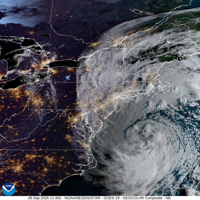
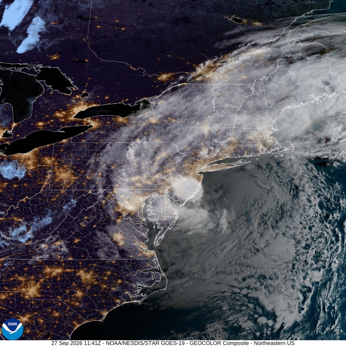
In this morning's satellite picture, we can see the comma shape that distinguishes a classic nor'easter.

Help Wanted
Employment Wanted

Latest Jobs
Employment Wanted
-
Family Assistant | Household Organization, Errands & Everyday Support.
Oct 9, 2026 at 1:09pm
-
Oct 5, 2026 at 4:22pm
-
Math Tutoring with Certified Teacher
Oct 1, 2026 at 11:04am
-
SAT Math, ACT and PSAT Math Tutoring with Certified Teacher
Oct 1, 2026 at 11:04am
-
Reliable & House Cleaning Services
Sep 29, 2026 at 10:38pm
-
Sep 29, 2026 at 11:02am
-
Professional Household Manager
Sep 28, 2026 at 12:08am
-
Sep 28, 2026 at 12:06am
-
Sep 27, 2026 at 9:22pm
-
Sep 26, 2026 at 6:26pm
Help Wanted
-
Oct 12, 2026 at 9:25pm
-
NANNY Needed - 30 hours a week
Oct 12, 2026 at 8:28pm
-
Oct 12, 2026 at 12:18pm
-
Part Time Driving Nanny in New Providence
Oct 12, 2026 at 10:22am
-
Oct 12, 2026 at 9:58am
-
Oct 9, 2026 at 7:33pm
-
Help Wanted Nannies, Babynurses, Caregivers (973)-342-3426
Oct 9, 2026 at 1:51pm
-
Very Rewarding Position as a Dog Walker/Pet Sitter
Oct 9, 2026 at 10:17am
-
SHF543 Short Hills Full Time Nanny/Family Assistant for three children ages 6, 2, and 5 Months 07078
Oct 8, 2026 at 9:40am
-
Oct 6, 2026 at 7:38am
Sponsored Business





Promote your business here - Businesses get highlighted throughout the site and you can add a deal.
Advertisement



Wed September 9th
Today, mostly sunny, high upper 80⁰s, breezy this afternoon and evening.
Tonight, slight chance of a shower, low mid 70⁰s
Thursday, humid, breezy, clouds and sun, high mid 80⁰s, overnight slight chance showers, low mid 60⁰s
Friday and Saturday, more sun than clouds, cooler, might hit 80⁰, not as humid, low mid 60⁰s
Sunday, might rain but nothing serious so far